Sep 30 2014
The conversion of forests, grasslands, shrublands and wetlands to cropland over the course of three centuries profoundly changed the surface of the Earth and the carbon cycle of the terrestrial ecosystem in Northeast China.
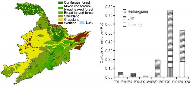
 The image on the left depicts a reconstruction of pre-agriculture land cover, and the chart on the right shows carbon emissions from forest, grassland, wetland, and shrubland. Credit: ©Science China Press
In a new study published in the Beijing-based journal SCIENCE CHINA Earth Sciences, a team of researchers from Beijing Normal University, Nanjing University of Information Science & Technology, and the Institute of Geographic Sciences and Natural Resources Research of the Chinese Academy of Sciences, present new calculations on carbon emissions triggered by the expansion of cropland in this region between 1680 and 1980.
"Using regional land cover reconstructions from historical records, with a bookkeeping model, we estimated the carbon sink changes caused by historical cropland expansion in Northeast China during the past 300 years," state researchers Li Beibei, Fang Xiuqi, Ye Yu and Zhang Xuezhen.
In a new study titled, "Carbon emissions induced by cropland expansion in Northeast China during the past 300 years," these researchers state that during the three centuries until 1980, approximately 38% of the grassland and 20% of the forest and shrubland were converted to cropland.
"The carbon emission induced by cropland expansion between 1683 and 1980 was 1.06–2.55 Gt C(gigaton of carbon)," they state..
"The primary source of carbon emissions was forest reclamation (taking 60% of the total emissions in the moderate scenario), the secondary source was grassland cultivation (taking 27%), and the tertiary sources were shrubland and wetland reclamation (taking 13%)," they add.
"The carbon emission estimation in this study was lower than those in previous studies," they explain, "because of the improved land use data quality and various types of land use change considered."
These researchers reconstructed land cover during the period 1680-1980 by consulting historical documents including government files, Russian investigations in Northeast China, documents of the Manchurian Railway, and official statistics.
Both deforestation and grasslands reclamation for agricultural development has triggered large carbon emissions into the atmosphere. Land cover across Northeast China experienced dramatic changes during that period because of large-scale migration and agricultural development.
After Manchu warriors seized control of Beijing in 1644, they established the Qing Dynasty but closed off their homeland in northern Manchuria to migration by common Han Chinese citizens.
"The Qing Dynasty government then changed its policy from prohibiting to encouraging Han's migration for agriculture in the second half of the 19th century," state the researchers.
“The Hans’ migration and subsequent land reclamations resulted in a rapid increase of carbon emissions to 0.197 Gt C in 1850–1899, 0.758 Gt C in 1900–1949, and 0.371 Gt C in 1950–1980,” they explain.
From 1683 to 1980, between 35.5×10³ and 97.4×10³ square kilometers of forest were converted into cropland, along with 93.4×10³ to 94.7×10³ square kilometers of grassland, 23.1×10³ to 61.8×10³ square kilometers of shrubland, and 10×103 to 11.1×10³ square kilometers of wetland.
Migration and the conversion of forests and grasslands into cultivated land proceeded northward, through what are now called Liaoning Province, Jilin Province, and Heilongjiang Province, from the end of the 1800s onward.
"Since 1900," the co-authors of the new study explain, "carbon emissions from Heilongjiang Province have greatly increased and even exceeded the total emissions of the other two provinces."
"During the 20th century," they add, "the largest increase in cropland occurred in Heilongjiang Province."
The co-authors of the new paper also explain that while previous studies focused mainly on carbon emissions from land use changes in terms of forest ecosystems, their research found that the conversion of non-forest ecosystems likewise played an important role in developing cropland and triggering carbon emissions.
"The carbon loss per unit area of the forest reclamation was larger than that in other, non-forest ecosystems, which caused the estimation in this study to be lower than Houghton et al.'s (2003) and Ge et al.'s (2008a) estimates," they state.
"The estimates of emissions from this study were lower than those from Houghton et al. (2003) and Ge et al. (2008a)," they add, "because this study used higher spatial resolution land use data based on historical documents and included disturbances of non-forest ecosystems such as steppe, shrub, and swamp."