New research from scientists at the Monterey Bay Aquarium Research Institute (MBARI) and their collaborators is the first to record how the melting of permafrost, submerged underwater at the periphery of the Arctic Ocean, is impacting the seafloor. The study article appeared in the March 14th, 2022 issue of the journal Proceedings of the National Academy of Sciences.
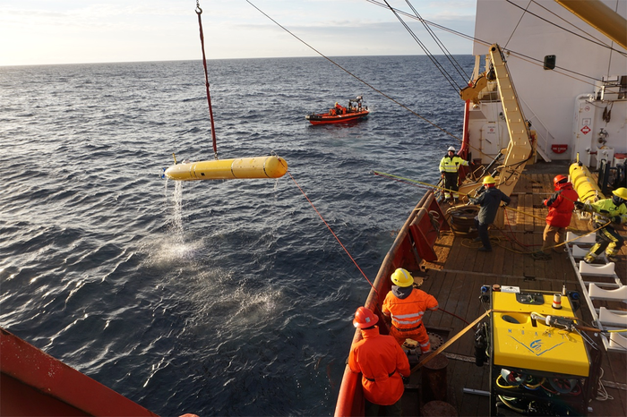
 MBARI’s autonomous underwater vehicle (AUV) is recovered after completing a successful seafloor mapping mission in the Arctic Ocean. The remotely operated vehicle (ROV, foreground) is used to conduct visual surveys of the newly mapped seafloor. Image Credit: Charlie Paull © 2016 MBARI
Several peer-reviewed research demonstrates that melting permafrost causes unsteady land which negatively affects vital Arctic infrastructure, such as buildings, roads, train tracks and airports. To repair this infrastructure is expensive, and the costs and impacts are projected to keep on increasing.
MBARI researchers and their partners, using modern underwater mapping technology, showed that vivid changes are taking place in the seafloor because of the melting permafrost. In certain areas, deep sinkholes have developed, some bigger than a city block with six-story buildings. In other areas, ice-filled hills known as pingos have formed from the seafloor.
We know that big changes are happening across the Arctic landscape, but this is the first time we’ve been able to deploy technology to see that changes are happening offshore too. This groundbreaking research has revealed how the thawing of submarine permafrost can be detected, and then monitored once baselines are established.
Charlie Paull, Study Lead Author and Geologist, MBARI
While the deterioration of terrestrial Arctic permafrost is linked partly to surges in mean yearly temperature from human-triggered climate change, the variations the researchers have recorded about the seafloor related to submarine permafrost originate from much older, slower climatic shifts associated with Earth’s emergence from the last ice age.
For thousands of years, comparable changes seem to have been taking place along the seaward boundary of the former permafrost.
There isn’t a lot of long-term data for the seafloor temperature in this region, but the data we do have aren’t showing a warming trend. The changes to seafloor terrain are instead being driven by heat carried in slowly moving groundwater systems.
Charlie Paull, Study Lead Author and Geologist, MBARI
“This research was made possible through international collaboration over the past decade that has provided access to modern marine research platforms such as MBARI’s autonomous robotic technology and icebreakers operated by the Canadian Coast Guard and the Korean Polar Research Institute,” explained Scott Dallimore, a research scientist for the Geological Survey of Canada, Natural Resources Canada, who led the study with Paull.
The Government of Canada and the Inuvialuit people who live on the coast of the Beaufort Sea highly value this research as the complex processes described have implications for the assessment of geohazards, creation of unique marine habitat, and our understanding of biogeochemical processes.
Scott Dallimore, Study Lead Author and Research Scientist, Geological Survey of Canada, Natural Resources Canada
Background
The Canadian Beaufort Sea, a remote location of the Arctic, has only just become accessible to researchers as climate change controls the retreat of sea ice.
Since 2003, MBARI has been part of a global partnership to explore the seafloor of the Canadian Beaufort Sea with the Department of Fisheries and Oceans Canada and the Geological Survey of Canada. In 2013, the Korean Polar Research Institute joined MBARI as a partner.
MBARI employed ship-based sonar and autonomous underwater vehicles (AUVs) to map the bathymetry of the seafloor as far as a resolution of a 1-m square grid, or approximately the size of a dining table.
Paull and the group of scientists will go back to the Arctic this summer aboard a Korean icebreaker, the R/V Araon. This voyage with MBARI’s long-time Korean and Canadian partners — together with the United States Naval Research Laboratory — will help improve upon current knowledge into the deterioration of the submarine permafrost.
Two of MBARI’s AUVs will chart the seafloor in extraordinary detail and MBARI’s MiniROV — a portable remotely worked vehicle — will facilitate additional exploration and sampling to match the mapping surveys.
This study received support from the David and Lucile Packard Foundation, Geological Survey of Canada, Fisheries and Oceans Canada, and the Korean Ministry of Ocean and Fisheries (KIMST grant No. 1525011795).
Journal Reference:
Paull, C. K., et al. (2022) Rapid seafloor changes associated with the degradation of Arctic submarine permafrost. Proceedings of the National Academy of Sciences. doi.org/10.1073/pnas.2119105119.