Dec 4 2008
A new and improved tool to monitor deforestation and degradation in tropical forests has just gotten a huge boost. The Gordon and Betty Moore Foundation has awarded the Carnegie Institution's Department of Global Ecology with a $1.6-million grant to expand and improve CLASLite (The Carnegie Landsat Analysis System Lite), a new, user-friendly method that enables even the smallest governments and non-governmental organizations (NGOs) to map tropical forests from their desktops. The technology will rapidly advance deforestation and degradation mapping in Latin America, and will help rain forest nations better monitor their changing carbon budgets.
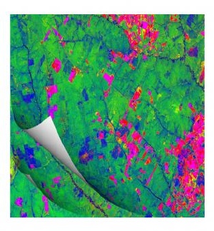
 This output from CLASLite shows deforestation (bare soil) in pink and forest disturbance from logging in blue in the Brazilian Amazon. The map depicts changes through time with each successive overlay. Image provided by the Asner lab.
"About 20 percent of global greenhouse gas emissions come from deforestation and degradation of tropical forests," remarked project leader Greg Asner. "And much of it occurs in developing nations, where monitoring capabilities are often unavailable to governments and NGOs. This grant allows us to improve and expand CLASLite, and to train many people from tropical forest nations so that they can determine where and when forest losses are occurring. Perhaps most importantly, rain forest nations will be able to better determine how much CO2 comes from deforestation and degradation—information that has been very scarce in the past. We hope that CLASLite will become a central tool for rain forest monitoring in support of global carbon crediting for REDD—the United Nations initiative on Reduced Emissions from Deforestation and Degradation."
The first land observation satellite "Landsat" was launched in the early 1970s, but the image analysis techniques employed at the time could not easily penetrate the upper layers of forest leaves. Beginning in 1999, Asner and colleagues started analyzing satellite imagery of Brazilian rain forests using CLAS's advanced computational methods and pattern-recognition algorithms. Their techniques allow the penetration of the canopy at a scale of about 100 square feet. The intricate computations detect small differences in vegetation patterns, producing detailed and stunningly beautiful forest maps. CLASLite works with the old and new Landsat satellites, as well as several other NASA sensors in Earth orbit.
The Asner group spent years improving CLAS in Brazil. Applying their advances, they were able to complete a study in Peru in just one year. Shortly thereafter they took CLAS to Borneo and have made it increasingly user friendly with a newer CLASLite system, designed for a desktop environment. David Knapp, a senior scientific programmer in Asner's group, has been a key figure in the CLASLite development, noting that " we have learned through the training of new users of CLASLite that forest monitoring can become an everyday activity that no longer requires huge investments in computers or expertise. This is our goal."
"Given the increased interest and activity for simple forest monitoring methods and rising emphasis on the monitoring needs around REDD, CLASLite, is clearly a strategic tool," remarked Luis Solorzano, the Andes Amazon Lead and Director for South American Programs at Moore. "Dr. Asner and Carnegie are uniquely positioned to deliver this state-of-the-art technology to the right end-use organizations both in government and civil society working to conserve and manage Andes-Amazon forests. We fully support his vision for a full and transparent deployment of CLASLite across the Andes Amazon region with an emphasis on securing its accessibility by all stakeholders."
This grant will support Asner's efforts to provide training and technology transfer in most tropical forest nations in the Andes-Amazon region, stretching from Venezuela and Guyana across to Peru, Ecuador, and Bolivia.