Jul 18 2019
In the last 22 years, sea levels in the Arctic have increased by an average of 2.2 mm every year, concluded a Danish-German research group after assessing 1.5 billion radar measurements of different satellites using uniquely designed algorithms.
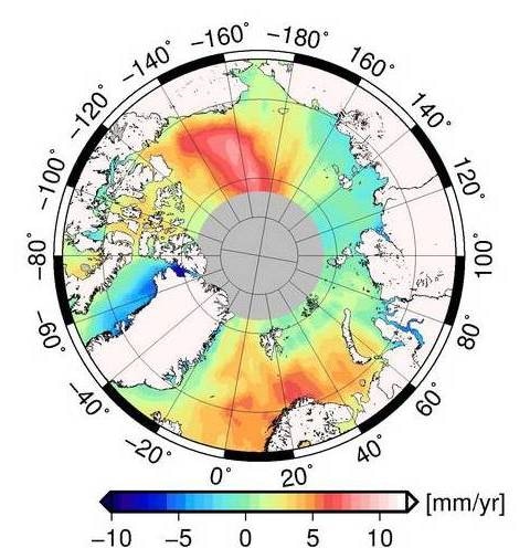
 The map illustrates that the average change in the Arctic sea level varies regionally. (Image credit: DTU/DGFI-TUM)
The Arctic is a hotspot of climate change. Due to rising temperatures, the glaciers of Greenland are receding. At the same time, sea ice is melting. Every year, billions of liters of meltwater are released into the ocean.
Prof. Florian Seitz, German Geodetic Research Institute, Technical University of Munich (TUM)
The large quantity of freshwater discharged in the Arctic not just raises the sea level but also holds the potential to modify the system of global ocean currents—and therefore, the climate.
However, at what rate do sea levels rise? And exactly what impact does this have? In order to find solutions to these questions, oceanographers and climatologists need precise measurements over a possible extended period.
In a joint effort, scientists from the Technical University of Denmark (DTU) and from the TUM have currently recorded sea-level variations in the Arctic over more than 20 years.
This study is based on radar measurements from space via so-called altimetry satellites and covers the period from 1991 to 2018. Thus, we have obtained the most complete and precise overview of the sea-level changes in the Arctic Ocean to date. This information is important in terms of being able to estimate future sea levels associated with climate change.
Stine Kildegaard Rose, PhD, Researcher, DTU Space
Finding Water with Algorithms
“The challenge lies in finding the water signals in the measured data: Radar satellites measure only the distance to the surface: Albeit, vast areas of the Arctic are covered with ice, which obscures the seawater,” describes Dr Marcello Passaro.
The TUM scientist has designed algorithms to assess radar echoes reflected from the water where it contacts the surface through cracks in the ice.
The homogenized and processed measurements will allow climate researchers and oceanographers to review and improve their models in the future.
Dr Marcello Passaro, Scientist, German Geodetic Research Institute, TUM
With the help these algorithms, Passaro processed and homogenized 1.5 billion radar measurements from the Envisat and ERS-2 satellites. Based on the signals traced at the TUM, the DTU group worked on the post-processing of these data and incorporated the measurements obtained by the current CryoSat radar mission.
From Monthly Averages to a Climate Trend
The scientists created a map with lattice points to show the monthly sea-level elevations for the period from 1996 to 2018. The long-term trend is shown by the sum of the monthly maps: The Arctic sea level increased by an average of 2.2 mm per year.
However, there are considerable regional variations. Within the Beaufort Gyre, north of Greenland, Canada, and Alaska, sea levels increased two times faster than average—over 10 cm in 22 years.
The reason is that the low-salinity meltwater accumulates in this place, while a steady east wind creates currents that stop the meltwater from combining with other ocean currents. By contrast, along the coast of Greenland, the sea level is decreasing—on the west coast by over 5 mm per year, as the melting glaciers deteriorate the attractive force of gravity there.
“The homogenized and processed measurements will allow climate researchers and oceanographers to review and improve their models in the future,” concludes Passaro.