Aug 21 2008
When you hear the word "NASA," do visions of rocket ships dance in your head? Well think again. From now on, it's "earthworms."
That's right. Using space technology, NASA is now studying the realm of earthworms, millipedes, and springtails -- the soil beneath your feet -- with a project called OMEGA (Observing Microwave Emissions for Geophysical Applications).
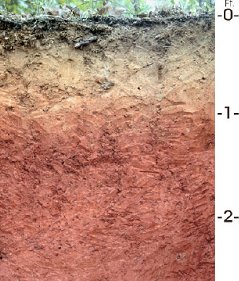
 A subterranean cross-section of Alabama soil. Credit: USDA
Why would an agency whose cosmic vision knows no bounds care about the nitty-gritty crawling-grounds of lowly critters? Because NASA recognizes the vital role this "underworld" plays in our lives on Earth. For instance, if forecasters don't know how damp or dry the soil is, they can't accurately predict the weather.
"OMEGA soil moisture data will help us build better weather models," says NASA scientist Chip Laymon, principal investigator for the OMEGA project at the National Space Science and Technology Center in Huntsville, Alabama. "Better models mean better forecasts."
But there's more. According to Laymon, this research could help forecasters predict flash floods, land-slides and drought. OMEGA could also help farmers plan crop planting, make important decisions about irrigation, and predict crop yields.
How will OMEGA scientists gather the soil moisture data? "We use a microwave radiometer," says Laymon. Ordinary soil naturally emits a small amount of low-energy microwave radiation; all warm objects do. "By analyzing those microwaves we can tell how much moisture is in the soil."
The name of the instrument is MAPIR, short for Marshall Airborne Polarimetric Imaging Radiometer, and it's about to fly on its first mission onboard a NASA P-3 aircraft. "Our instrument has to be ready to install on the P-3 by Sept. 15," says Laymon. "We'll then fly missions over the Delmarva Peninsula between Oct. 1 and Oct. 14."
The Delmarva Peninsula, a 180 mile x 60 mile area of land on the east coast of the United States bounded by the Chesapeake Bay and the Atlantic Ocean, is a good place for MAPIR's maiden flight. Two-thirds of the peninsula is agricultural and one-third forested, so there is a variety of terrain to sample. Moreover, the USDA Agricultural Research Service has already been studying the area and they have set up their own moisture sampling stations. These can provide valuable "ground truth" comparisons for MAPIR's airborne data.
MAPIR's berth on the P-3 was an unexpected development. "Another mission slated to fly on the P-3 scrubbed, and a slot suddenly opened for us," says Laymon. "We've really had to accelerate our schedule for developing MAPIR. The intensity of the schedule is enormous -- trying to refocus and prepare for airworthiness reviews and other milestones. The team has worked tirelessly and we have many more long days to come."
The ultimate goal is three tiers of observation: OMEGA instruments on a truck and a plane, and a similar instrument built by NASA's Jet Propulsion Laboratory, on a satellite. Each sensor will tell the story of soil moisture from its own unique perspective. The truck, with its own huge microwave antenna, is almost ready. The satellite will most likely be in the form of the 2013 Soil Moisture Active Passive, or SMAP, space mission led by JPL. After the P-3 test-flight, OMEGA's regular plane will be a Polish-built Antonov aircraft, a big beefy biplane housed at a local airfield, affectionately known to the team members as "the flying tractor."
"With this aircraft, we'll be able to do a lot of research locally. I expect 'the flying tractor' to be airborne before the end of the year," says Laymon.
Meanwhile, the rush to prepare for the upcoming P-3 flights has strained OMEGA researchers to the max. What's the hardest part? "Oh, probably the hallucinations from stress and lack of sleep," grins Laymon. No matter how hard he tries, he can't stop thinking about flying tractors and a universe of earthworms.