Oct 15 2009
The combined global land and ocean surface temperature was the second warmest September on record, according to NOAA’s National Climatic Data Center in Asheville, N.C. Based on records going back to 1880, the monthly National Climatic Data Center analysis is part of the suite of climate services NOAA provides.
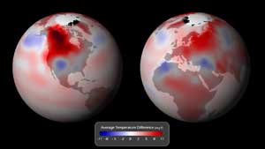
 Global surface temperature anomalies (degrees F) for the month of September 2009
NCDC scientists also reported that the average land surface temperature for September was the second warmest on record, behind 2005. Additionally, the global ocean surface temperature was tied for the fifth warmest on record for September.
Global Temperature Highlights
The combined global land and ocean surface temperature was 1.12 degrees F above the 20th century average of 59.0 degrees F. Separately the global land surface temperature was 1.75 degrees F above the 20th century average of 53.6 degrees F.
Warmer-than-average temperatures engulfed most of the world’s land areas during the month. The greatest warmth occurred across Canada and the northern and western contiguous United States. Warmer-than-normal conditions also prevailed across Europe, most of Asia and Australia.
The worldwide ocean temperature tied with 2004 as the fifth warmest September on record, 0.90 degree F above the 20th century average of 61.1 degrees F. The near-Antarctic southern ocean and the Gulf of Alaska featured notable cooler-than-average temperatures.
Other Highlights
Arctic sea ice covered an average 2.1 million square miles in September - the third lowest for any September since records began in 1979. The coverage was 23.8 percent below the 1979-2000 average, and the 13th consecutive September with below-average Arctic sea ice extent.
Antarctic sea ice extent in September was 2.2 percent above the 1979-2000 average. This was the third largest September extent on record, behind 2006 and 2007.
Typhoon Ketsana became 2009’s second-deadliest tropical cyclone so far, claiming nearly 500 lives across the Philippines, Cambodia, Laos and Vietnam. The storm struck the Philippines on September 26, leaving 80 percent of Manila submerged.
Scientists, researchers, and leaders in government and industry use NCDC’s monthly reports to help track trends and other changes in the world's climate. The data have a wide range of practical uses, from helping farmers know what and when to plant, to guiding resource managers with critical decisions about water, energy and other vital assets.
NOAA understands and predicts changes in the Earth's environment, from the depths of the ocean to the surface of the sun, and conserves and manages our coastal and marine resources.