Nov 2 2009
NOAA scientists took off Saturday on the second phase of a mission that, when complete, will provide a detailed view of how carbon dioxide and other greenhouse gases are distributed globally. Monitoring the increasing levels of greenhouse gases and black carbon aerosols in the atmosphere is crucial to understanding human-caused climate change.
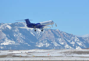
 HIPPO mission taking off on Saturday, Oct. 31, in Broomfield, Colo.(Credit: NOAA)
“Missions such as this one are critical to understanding the impacts of greenhouse gases and particulates,” said Jane Lubchenco, Ph.D., under secretary of commerce for oceans and atmosphere and NOAA administrator. “The data collected are also essential to help verify if policies to reduce these heat trapping pollutants are having their intended effect.”
Fred Moore and Ryan Spackman, researchers from NOAA’s Cooperative Institute for Research in Environmental Sciences (CIRES), took off early Saturday with five NOAA Earth System Research Laboratory (ESRL) instruments on a modified Gulfstream aircraft. Their roller-coaster tour of the planet will take them from pole to pole, dipping and climbing repeatedly between altitudes of 1,000 feet and 47,000 feet. ESRL and CIRES, a joint institute of the University of Colorado and NOAA, are located in Boulder, Colo.
Their flights, planned to continue through December, are part of the HIPPO Mission, a multiagency, multiyear effort to paint a three-dimensional portrait of the atmosphere. HIPPO, for HIAPER Pole-to-Pole Observations of Greenhouse Gases, is funded and operated jointly by the National Science Foundation, the National Center for Atmospheric Research, and NOAA. HIAPER – the High-performance Instrumented Airborne Platform – is the NSF’s Gulfstream V aircraft.
Steve Wofsy of Harvard University is leading HIPPO with a team of scientists from NOAA, NCAR, Scripps Institution of Oceanography, Jet Propulsion Laboratory, University of Miami, and Princeton University.
“While we have ground-based stations that measure carbon dioxide at specific locations, HIPPO is giving us a view of how carbon dioxide is distributed globally at different altitudes and during different seasons,” said Jim Elkins, Ph.D., a NOAA ESRL atmospheric physicist. The team is pleased with the success of the first phase of HIPPO flights last January, which gathered data in cross-sections of the atmosphere from pole to pole, he said.
Information gathered during these flights will be critical for both climate modelers seeking to understand Earth’s future and policymakers who rely on accurate science for decision-making. This research and decades of greenhouse gas monitoring are part of NOAA’s suite of climate services.
Three more sets of flights are planned over the next two years to fill in additional data during different seasons and from areas where few previous measurements have been made. HIPPO’s second phase will cover the central and eastern Pacific, departing from Colorado with stops in Alaska, Hawaii, Rarotonga of the Cook Islands, New Zealand, Australia, and the Solomon Islands. A fly-over of the NOAA American Samoa observatory is also planned.
NOAA scientists have been monitoring greenhouse gases through a ground-based, global network for nearly 40 years. As these gases move up through different layers of the atmosphere, they may persist for a time or be altered or destroyed in the upper atmosphere. The HIPPO Mission flights will give scientists a clearer picture of the distribution of greenhouse gases throughout the atmosphere.
NOAA scientists designed five instruments for analyzing air samples onboard HIPPO flights. They have the ability to detect and measure more than 30 major and minor greenhouse gases as well as water vapor, ozone, and soot particles.
“We are providing flight planning and weather support, measurements of all greenhouse gases and some carbon isotopes, and in-flight measurement of non-carbon dioxide greenhouse gases and black carbon,” Elkins said.
Eric Hintsa of CIRES and Elkins will be flying on subsequent legs of HIPPO phase II. Other scientists involved in leadership, flight planning and overall coordination on the ground are Steven Montzka, David Fahey, Ru-shan Gao, and Karen Rosenlof of NOAA, and Geoff Dutton, Molly Heller, Ben Miller, J. David Nance, Eric Ray, Joshua Schwarz, Colm Sweeney, Jack Higgs, and Sonja Wolter of CIRES.
NOAA understands and predicts changes in the Earth’s environment, from the depths of the ocean to the surface of the sun, and conserves and manages our coastal and marine resources.