Nov 19 2014
Scientists from the WCS (Wildlife Conservation Society), NASA, and other organizations have partnered to focus global attention on the contribution of satellites to biodiversity conservation in a recently released study entitled "Ten Ways Remote Sensing Can Contribute to Conservation," featured in the latest edition of the scientific journal Conservation Biology.
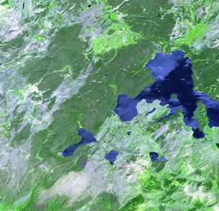
 A remote sensing image of Yellowstone National Park, regarded by many as the world's first national park. WCS, NASA, And other conservation and remote sensing agencies, universities and NGOs are focusing on the top 10 conservation questions for satellite technology, including the monitoring of protected areas from space. Credit: NASA/GSFC/METI/ERSDAC/JAROS, and US/Japan ASTER Science Team.
Addressing global questions requires global datasets that are enabled by satellite remote sensing; this paper highlights the way in which continuous observations of the Earth's surface and atmosphere can advance our understanding of how and why the Earth is changing and inform actions that can be taken to halt the degradation of planet's natural systems.
The findings of the paper will inform discussions on improving protected area management that are underway at the IUCN World Parks Congress, an event held every 10 years by the global conservation community.
Established in many cases to conserve wildlife and the ecosystems they inhabit, protected areas still fall short of protecting species and their ecological needs. In many instances, protected areas such as Nouabalé-Ndoki National Park in The Republic of Congo do not cover the full range of species such as elephants. Remote sensing can be used to gather information needed for managing landscapes beyond protected area networks.
"Remote sensing data from orbiting satellites have been used to measure, understand, and predict environmental changes since the 1970s, but technology that subsequently became available can now be applied much more widely on a whole range of conservation issues," said WCS Conservation Support scientist Dr. Robert Rose, the lead author of the study. "To that end, we sought out the top thought leaders in conservation and the remote sensing community to identify the best conservation applications of these data."
"Collaborations such as these that strengthen ties between disparate research communities will create new opportunities to advance conservation," said co-author Dr Allison Leidner of NASA's Earth Science Division. "For example, it will help remote sensing scientists tailor their research to meet the needs of field-based researchers and conservation practitioners."
With funding from NASA to lead the study, Rose and his co-authors brought together 32 thought leaders from both the conservation and remote-sensing communities. The participants interviewed more than 100 experts in both fields and generated 360 questions, which were then whittled down to the Top 10 conservation examples on how remote sensing can be used, including:
- Species distribution and abundances
- Species movements and life stages
- Ecosystem processes
- Climate change
- Rapid response
- Protected areas
- Ecosystem services
- Conservation effectiveness
- Agricultural/aquiculture expansion and changes in land use/cover
- Degradation and disturbance regimes
With this study, the authors hope to jumpstart a new collaborative initiative that provides guidance to space agencies and other partners on how future Earth observation satellite missions can contribute to advancing wildlife protection and protected area management. Toward that end, the authors initiated the Conservation Remote Sensing Network, which currently has 350 members from around the world, all of whom are interested in applying remote-sensing data to a broad array of conservation challenges.
"A vital part of this new network, which will foster communications and build opportunities between the conservation and remote sensing communities and help develop new remote sensing capabilities, will be to generate interest from both the public and private sector to invest in the use of orbiting Earth observatories to help conserve the planet's remaining biodiversity," added Dr. David Wilkie of WCS's Conservation Support Program.